Welcome Aboard Mariners Alike - Malaysia Rule The Waves

its hard to describe how a man could left everything he had on land and went out to sea...
its even harder to describe how bright the stars at night and how fresh the cool morning air when you are in the middle of the ocean...
the hardest thing is to describe how close you are to death and how god could took your life at any time...
come to sea and see for yourself...

GOD SPEED AND FAIR WINDS


come to sea and see for yourself

this blog is dedicated to mariners,navigators and seafarers alike, merchant or naval for others to had a glimpse of what we do and what we faced in the vast blue oceans.

Disclaimer :
Please inform in advance the owner of this site if you tend to use any postings entitled or labeled "story of watch keeping officer"..."nautical studies" and "panorama di laut biru" in this site for your website or for any other purposes.

The owner could be contacted through Facebook or email at kartefower_444@yahoo.co.uk

Thank you.
Showing posts with label marine technology. Show all posts

Thursday, May 20, 2010

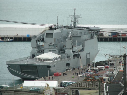
kapal best - HMNZS Canterbury (L-421)

entry for those who were looking for military sealift ship...yes...this include those from the RMN...this might be a good idea...scrap Dokdo...its too expensive...


HMNZS Canterbury (L-421) multi role vessel

this is New Zealand navy first strategic sealift ship...ok this is not breaking news since the NZ had been using this ship circa 2007...

NZ navy been looking for replacement for its previous sealift vessel..the Charles Upham which failed to aquire funding for refit...the new programme under the name Project Protector is to maintain sealift capability in the South Pacific...the project also include a number of offshore and inshore patrol vessel....

back to the Canterbury...

HMNZS Canterbury (L-421) is a 9000 tonne..131metre length multi role vessel build based on civillian Roll On Roll Off vessel...designed by Merwede Shipyard of Netherlands and subcontracted to Tenix of Australia...keel was laid on September 6th 2005 and completed in February 2006...her hull is ice strengthened which gave her the ability to operate in sub antarctic waters

nice looking warship....nice one....


She is propelled by 2 Wartsila CODADE engine capable of moving at baseline speed of 19.6 knots and economic speed of 16 knots..covering 8000Nm...and armed with 1 x Remote Controlled MSI DS25 Stabilized Naval Gun with 25mm M242 Bushmaster cannon and 2 x .50 calibre machine guns


one of many types of military vehicle which could be carried by Canterbury..the NZLAV...cool APC eh..haha


HMNZS Canterbury had various facilities...ranging from a cargo space of 1,451 m² capable with possible loadout of various military vehicle which consist of14 Pinzgauer Light Operational Vehicles, 16 NZLAV light armoured vehicles, 7 Unimog trucks, 2 ambulances, 2 flat bed trucks, 7 vehicle trailers, 2 rough terrain forklifts, 4 ATV-type vehicles and up to 33 20ft TEU containers...a medical facilities...workshop...armoury and facilities to embark up to 8 containers containing explosives and 2 containers containing hazardous material with extensive sprinkler system...

The ship also had a hangar facilities and a helicopter deck capable of receiving a Chinook helicopter or up to 4 NH-90 helicopters...currently Canterbury operates the SH-2G Seasprite helicopter...

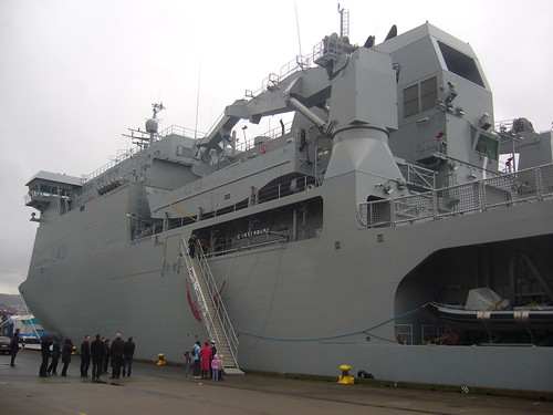
 landing craft and 60 tonne crane..port side...

 and her starboard side 60 tonne crane with landing craft...note the starboard side ramp forward..

stern ramp and helicopter deck..tent are for BBQ at night...hahahaa...

Landing craft are loaded on either both port and straboard side 60 tonne crane or via the stern ramps.

The nice looking warship of NZ navy is plagued with various problems...ranging from seaworthiness in heavy seas...fatigue on fittings plus the uncertainty and failure of Project Protector inshore and offshore patrol vessel programme...

what ever is it....this ship is considered "kapal best"..due to its civillian design induced for military ops...nice one...

-come to sea and see for yourself-

Monday, April 26, 2010

story of watchkeeping officer - the best radar observer in the fleet...

entri gelombang elektromagnetik radar kegunaan maritim...sila balut diri anda dgn aluminium foil utk mengelakkan diri dari terkena sinaran berbahaya...wahahaha....


 the worst best radar plotter in the fleet...wahaha..ambik course pun dua kali...best yg amat..

ini cerita pasal radar...bukan radar utk surface to air missile...buka radar AESA utk pesawat AWCS...juga bukan radar 3D...ini radar konvensional...dgn paparan CRT...dibina oleh syarikat radar Japan Radio Company...ataupun Racal Decca...utk kegunaan maritim...yakni utk kegunaan navigasi bg kapal2 merchant yg cintakan keamanan....hahaha....

jap2...amenda radar nih sebenarnya...??

radar bermaksud dalam RAdio Detection And Ranging...wahahaha...

atas kapal2 merchant ni...radar dia simple je...x complicated cam radar wat gi perang...tapi simple2 pun masih perlu lah jugak seorang navigator tu utk belajar apa itu radar time radar course dan ARPA course masa kat ALAM...course diambil masa semester 4 dan 5...kiranya lepas naik kapal dan lepas diajar oleh OOW korang apekah dinosaur yg dipanggil radar ini time korang wat watch tu...


 radar dinosaur zaman dulu2..kat ALAM nye radar room ade sebijik camni brand Furuno...pastu ade lg satu radar klasik besar brand JRC....dua2 radar dinosaur...lg tua dr aku...huhu

radar ni adalah teknologi yg dibangunkan oleh Germany dan UK...time perang dunia dulu...gunanya utk mengesan kehadiran pesawat2 pengebom dan pejuang...dan jugak sebagai mata bg kapal2 perang utk cari kapal perang musuh atau pesawat musuh 50-60 tahun lepas perang..skarang...kegunaan radar sungguh meluas dlm aspek navigasi dan peperangan sehinggakan macam2 versi baru dan teknologi radar baru diperkenalkan...supaya operator dpt mengesan dgn lebih tepat kedudukan satu2 sasaran....jet pun pkai radar..eh..polis pun ada radar gun...x caya tgk myhbuster...ngahahaa...

aiseh...dah mcm lecture lak...

ok..dalam ilmu pengunaan radar...navigator kne faham prinsip...prinsip dia sama asas nya dlm subjek fizik form 4...form 5 dulu...kalau blaja fizik laa...tp benda ni sains form 3 pun aku rasa ada...ok2...
  
korang pernah dok dalam dewan sekolah atau dalam bilik kosong...x pun dok dlm gua...bila kita cakap...akan keluar gema atau echo kan...tu yg suara jadi...tolong..long..long...hahahaa

prinsip echo ini digunakan pd radar..dimana gelombang elektromagnetik dipancarkan...akan patah balik ke scanner bila terkena satu objek...dari situ..jarak pergi dan balik gelombang itu dpt ditentukan...sbb masa bg satu2 gelombang tu dipancarkan dan halajunya sudah diketahui...ini kerja kira2 yg kena guna komputer...x lalu kita nk kira sbb kelajuan dan kekerapan gelombang yg dipancarkan tu dlm kiraan micro second....kalah jet laju dia...

maka digunakanlah formula asas...jarak = halaju x masa....

ok...tu sikit laa prinsip radar...ak x nk elaborate panjang2...nnt ada yg pening..muntah hijau sbb terlalu komplikated...aku pn pening...siap dua kali ambik exam radar...huahaha... 


 tu dia..kapal perang nye radar...ada 7 semua skali...amacam..??

kalau korang yg datang site aku ni...geng2 askar ke...atau yg minat pasal jet2 ke...AWACS ke kan..korang mesti pernah jumpa perkataan band...ini bukan rock band mahupun rubber band...apa lg band of brothers...band ni adalah jalur frekuensi...selalu yg aku pernah dengar askar guna Q-band radio ke kan...

utk radar maritim standard...jalur frekuensi yg digunakan scr meluas adalah X-band dan S-band...dimana frekuensi ini paling efektif kegunaannya bg tujuan navigasi...terutama dlm keadaan laut yg x menentu cuacanya...X-band ni frekuensi 10Ghz...digunakan pd radar 3cm...3cm ni bukan besar scanner dia tp jarak gelombang elektromagnetik yg dipancarkan setiap mikro saat...S-band lak menggunakan frekuensi 3Ghz...pd radar 10cm...

X-band radar sesuai utk mengesan target pd jarak dekat especially time coastal navigation...slalu 3 ke 6 batu nautika detection range yg diset...still ini bergantung pd navigator...nak set 2 batu nautika ke...1.5 batu ke kan...suka hati beliau lah...

radar ni lebih senang terganggu akibat hujan atau lain2 precipitation...sbb energy wave dia 3cm je panjang dia..so bila kena hujan energy wave die cepat hilang sbb terpantul2 oleh molekul2 hujan....dan tahap efektif radar ni berkurangan bila digunakan utk long range scanning...sbb energy dia sikit kurang cam aku cakap td...berbanding S-band...

ini display pd radar/ARPA monitor...S-band radar...course up display...sea stabilized..relative motion...

S-band lak lebih kpd long range detection...selalunya 12 batu nautika atau lebih...bg mengesan kehadiran kapal2 atau apa2 saja target dari awal utk membolehkan navigator utk ambik tindakan...compared to X-band...S-band adalah preferable radar bila dalam hujan atau apa saja precepitation...sbb energy wave dia 10cm...bila kena hujan...ade lg balance energy die...tp bila nk detect close range target....radar ni kureng skit..dah tu dia pun kerja skodeng awek yg jauh je...yg dekat2 sume disapu oleh X-band...wahahaha....

haha...dua2 radar X ngan S band ni ade pd mana2 kapal moden...satu utk long range..satu utk short range...wahaha

kapal perang je ade 4-6 bijik radar skali....I-band ada..Q-band ada..ini utk kejar bandit pakai ESSM...ngahahaha....


bertungkus-lumus kearah radar observer...ini kerja namanya radar plotting...

ok...radar ni ada seninya bila digunakan....iaitu radar plotting..

radar plotting adalah satu cara bilamana navigator mengesan satu2 target...perlu determine apakah kelajuan...heading dan closest point approach dgn target tu...korang penah blaja vektor time skolah dlu kan...haa itu lah benda nye...

maklumat2 yg dicari bila radar plotting ni adalah..

TLB - target last bearing :  bearing terakhir target masa observation..
TLR - target last range :  jarak terakhir target masa observation...
CPA - closest point approach :  jarak paling dekat dgn target..dikira dlm batu nautika
TTCPA -  time to closest point approach :  masa sblm smpai pd target..
TCPA  - time to closest point approach :  pukul berapa paling dekat dgn target..
TCO -  target course :  heading target tu berapa...
TSPD - target speed :  speed target tu berapa...
ASPECT - aspect :  ini penentuan samada target tu hijau ke merah...pasal ape ada kaler2 ni..nnt citer

plotting dibuat pd radar plotting sheet...atau pd plotting screen atas radar tuh....ini radar dinosaur zaman 70an je...skarang merchant xde radar yg plotting atas screen..tp navy..yg member aku bg tau...ade lg...waaah...klasik sial...

kiraan bg menentukan speed dan heading target..serta CPA target tu dibuat berdasarkan maklumat dr pemerhatian yg melibatkan heading relative target tu...selang masa atau interval satu2 observation dan speed serta heading kapal kita sendiri...dari maklumat ini...ia akan membentuk satu segi tiga vektor...yg pada akhirnya akan memberikan true speed and heading kapal target...dgn maklumat ni...barulah boleh cari CPA..TTCPA dan TCPA kapal tuh...

 radar plotting..dgn WOA triangle...siap CPA initial ngan CPA lepas reduce speed...

segitiga vektor tu dinamakan WOA triangle...dgn tiga komponen vektor berbeza..WO - utk kapal sendiri..WA utk target relative course dia...ngan OA iaitu target true course and speed...mcm dlm subjek vektor yg aku cakap tadi...perkara ni ade kerja melibatkan kira2...jadi modern math kena mantap..wahaha

yg best nye..skarang dah ada ARPA...atau automatic radar plotting system...ini radar plotting dibuat oleh komputer...so bila aquired target...xyah dah nak carik plotting sheet utk dapatkan speed atau heading kapal target tu...klik je target tu...pastu karang kuar complete info pasal kapal tu dlm radar kita...senang gila..

tapi...navigator masih lagi diajar plotting nih...sebab ARPA tu komputer...so bila nama dia machine..maka adalah kebarangkalian utk ianya kaputt...sbb aku pernah kena time kadet dlu...radar yg assisted by ARPA kaputt sblm masuk Gibraltar Straits...pergh...berkejar plot target weyh...kena back to basic balik...tp time tu aku nye plotting sungguh x accurate sbb x blaja lg...sental jek...wahahaa.....

ak balik dr kapal...silibus radar plotting ni lah yg paling pening time aku ambik radar course dulu...exam dia passing mark dia 70%..soalan ade 3...salah dua soalan fail...salah satu soalan pun boleh fail....pastu kalau nk ambik balik plottng exam nih...kena bayar RM350...ffuuuhh....

dalam radar course ni ada total 4 exam..iaitu written exam..radar plotting..oral exam ngan practical radar exam....oh..radar course ni...kalau fail dua dari empat empat exam...dikira gagal seluruh course..maka x dpt lah sijil radar..dan kenalah ambik balik course yg ditaja sendiri sebanyak RM1025.00...x termasuk accomodation dan makan minum...ini kat ALAM ok...lain tempat ak x sure camne...so jgn fail radar course...nnt xde duit...hahaha....

wahaha...

ak rasa..cukup kot psl radar ni...nk lg..masuk ALAM...xpun masuk askar...diaorang pun main radar2 nih...karang detail2 sgt bukan paham...lg org x baca....ngahahaha....

-come to sea and see for yourself-

Saturday, April 24, 2010

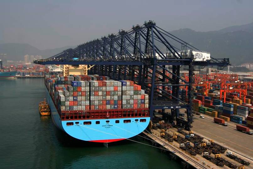
kapal best - Emma Maersk...dan adik2 nya...

entri kapal x perang...saya suka kapal kotak2 yg laju....


kapal kotak laju yg best..sebab dia awek Denmark...ngahaha...


ini Emma Maersk....kapal kontena paling panjang atas planet bumi ni dgn panjang 397.7m...berkapasiti 14 500 teu`s...kurang lebih..kapal ni best sebab dia lg panjang dari US nye carrier...yg panjang dia 321m je...asal dia dari Denmark..di bina di Odense Steel Shipyard...

kapal ni masa mula2 siap..adalah kapal kontena paling besar kapasiti Teu`s dan paling panjang dalam golongan kapal2 kontena...menyebabkan kapal2 kontena kompeni2 lain nampak lebih kiut dan lebih comel...

Emma Maersk ni jugak adalah kapal kotak yg laju...dia boleh ligan lebih dari 25 knots...dgn menggunakan enjin Wärtsilä 14RT-Flex96c berkuasa 109 000 hp dan menjana 80 megawatt kuasa...bersama2 lima generator Caterpillar 8M32 berkuasa 40 000 hp dan menjana 30 megawatt kuasa...enjin kapal ni saja berat dia 2300 tonne...so berat kapal ni mencecah 151 867 gross tonnage...

Emma Maersk - gambo cam nmpak kecik...nnt korang tgk dgn mata sendiri..besar sial...cam aircraft carrier...

kapal ni bukan sebijik je dalam class dia...lepas Emma Maersk siap tahun 2006..sister ship dia Estelle Maersk menyusul...pastu tahun 2007...lima bijik lagi keluar dari shipyard...dgn nama Ebba Maersk...Evelyn Maersk...Edith Maersk..Eleonora Maersk dan Elly Maersk....semuanya dgn panjang dah kapasiti Teu`s yg sama dgn Emma Maersk...kapal yg last...Eugen Maersk siap tahun 2008...so semua skali ade 8 bijik kapal kotak laju yg paling besar atas planet nih...8 beb...!!!

"this ship is freakin huge eh mate...?

yg best nye...kat Malaysia..satu tempat je kapal ni boleh alongside...then conduct loading/discharge kargo...Pelabuhan Tanjung Pelepas....ak ingat dekat semua laa kapal2 Emma dan adik2nya ni masuk sana....Singapore pn selalu gak kapal ni masuk...so orang2 Johor..heads up...kalau kapal kaler biru muda ni masuk je PTP...tangkap gambar...bkn senang weyh kapal paling besar atas planet bumi nk masuk Malaysia...

 masuk rotterdam...aku ambik gambo2 ni dari site http://rotterdamhaven.web-log.nl

oh..kpd geng2 seafarers yg kne pacak gi Rotterdam kat Melati class...siap2..kapal ni pun slalu lepak2 kat Rotterdam tu...wahahaha....

ak x leh bayang...nk gi forward station x lalu weyh kalau jalan kaki...kne beli skuter..xpun basikal...nak naik bridge pun tinggi gila...10 tingkat nk naik tangga...i`ll take the elevator lah...tipu la kapal besar ni xde elevator...Tenaga class yg ol skool tu pun ada...

tapi besar2 kapal ni..krew 13 orang je....tiga belas orang sahaja weyh utk kapal yg lg besar dari mana2 aircraft carrier dan panjang dia 100m lebih dari LNG carrier MISC....ak boleh bet kapal ni fully automated pd kebanyakan sistem...serius...

haha...tu dia kapal best...ni ak bg gambo adik2 Emma nih...

Evelyn Maersk..

Elly Maersk..

Estelle Maersk...

ini semua awek2 Denmark nih..Europe mari punya...best bwk gi dating kat Rotterdam ngan Bremerhaven ti summer...wahahaa...

sikit2 dah laa ak tunjuk kat korang...byk2 krg...ak lak x dpt..

-come to sea and see for yourself-

Saturday, March 13, 2010

MV Blue Marlin - mengangkut kapal dengan kapal...?

US nye Sea Based X-Band Radar...yg hangkut bende alah tu adalah kapal MV Blue Marlin..

tau tak korang dalam dunia ni ade kapal yg leh bawak kapal...x caye gi la tgk Discovery Channel...sumpah x bohong...

kapal ni dipanggil semi submersible heavylift vessel dlm bahasa penjajah...rupa die cam kapal yg x cukup besi..sebab kerajaan xde duit nak siapkan...huahaha...xde lah...deck kapal tu sengaja di buat gitu supaya leh diletakkan kapal..atau platform carigali minyak dan gas padanya..

oil platform pun die angkut...

kapal ni byk dimiliki oleh konsortium Belanda yg bernama Dockwise B.V..yg mengoperasikan kapal spt M.V Blue Marlin utk tugasan2 mega spt membawa platform carigali gas dan minyak luar pantai...selain terdapat juga kapal2 yg lebih kecil saiznya utk tugasan membawa perahu layar atau kapal2 yg rosak...


hangkut kapal..wohoho...


dlm Dockwise..kapal diaorg yg paling glamour adalah M.V Blue Marlin...kapal yg menjadi popular bila ia digunakan utk menyelamatkan kapal USS Cole yg kene tibai dgn terrorist...sebelum tu kapal ni byk wat keje angkat berat...ala2 malek noor utk bikin body six pack yg mantap...uik?

 semi-submersible...separa tenggelam...?

camne kapal ni bawak kargo super raksasa atas deck die tu...pakai kren kah...? ade lak ke kren yg besar kat laut nun..?? jawapannya kapal ni mmg x pkai kren..tp menggunakan tangki2 ballast utk meneggelamkan diri sendiri dlm air...isi air dlm ballast tank...kargonye di pandu ke atas deck yg dan tenggelam..diposisikan dgn ketepatan mencecah sentimeter pd poin2 yg tertentu...kemudian kapal ni kuarkan balik air dlm tangki ballast..dan voila...kargo atau kapal dah ade atas deck...sebab tu dipanggil semi-submersible heavy lift vessel..atau kapal pengangkut berat separa tenggelam..(pelik translation nye)

wahahaha...

-come to sea and see for yourself-

Monday, September 28, 2009

Icebreaker - Breaking Trough The Ice


breaking trough the polar ice caps

Icebreaker is a purpose built ship designed to navigate trough the ice covered waters.An icebreaker had a different traits from other vessels which is ice strengthened hull, ice clearing shape and much more power to push the vessel trough the ice-covered water.

It is used to keep trade routes navigable by other vessels in the polar region or in areas where seasonal ice conditions exists.Some icebreakers are also polar research vessels engaged in scientific and oceanographic researches in the polar regions.Icebreakers like the RV Polarstern are deeply involved in scientific researches.

There are also multipurpose icebreaker engaged in offshore oil and gas industries as well as ice strengthened vessels where it is a cargo vessel designed to withstand ice without having the assistance of traditional icebreakers.

  the arktika class icebreaker riding over the ice to open up shipping lane during winter season

Icebreakers use its enormous size and weight to break the ice covered water by riding up and over the ice in front of it with the weight of the ship then breaking the ice.

The combination of momentum and power drive the vessel on to ice and breaking it under the immense weight of the vessel.The ship had specially designed hull to direct the broken ice around or under to keep it away from the ship propeller or propeller shaft thus clearing the debris out from the ship path.

Double hull constructions and watertight compartments protects the icebreaker from taking in water in case of hull breach with the hull thickness is greater than normal seagoing.This is most notable at the bow,stern and along the vessel waterline.

the strengthened bow of an icebreaker differs from normal vessels

The bow is rounded rather than pointed, allowing the vessel to ride up over the ice, breaking it with the weight of the vessel. The hull has no appendages likely to be damaged by the ice, and the rudder and propeller are protected by the shape of the hull. The propeller blades are strengthened, and the vessel has the ability to inspect and replace blades while at sea.
Azimuth Podded Propulsion (azipods) are a norm in new type of icebreakers where these propulsion systems give the ship a much greater manoueverability and increase fuel efficiency.This has permitted the vessel from the reliance of rudder.
 
RV POLARSTERN


RV Polarstern of the Alfred Wagener Institute for Polar and Marine Research,Bremerhaven


Displacement:
17,300 Tonnes
Length:
117.91 metres (386 ft 10 in)
Beam:
25.07 metres (82 ft 3 in)
Draught:
11.21 metres (36 ft 9 in)
Installed power:
4 engines, 14,000 kW (20,000 bhp)
Speed:
15.5 knots (28.7 km/h)
Capacity:
44 maximum


Built by Howaldtswerke-Deutshce Werft in Kiel, the Polarstern is involved in marine and scientific researches in the Arctic and Antartic region. The double hull research vessel can operate in temperature as low as -50°C and breaking trough ice 1.5m thick at speed of 5 knots.


 USCGC HEALY (WAGB-20)


USCGC Healy of the United States Coastguard

Displacement:
16,000 tonnes
Length:
130 m
Beam:
25 m
Ice class:
1.4 m @ 3 kn (5.6 km/h; 3.5 mph) continuous
2.4 m backing and ramming
Propulsion:
Diesel - Electric
Speed:
17 knots
Complement:
76 crew, 50 scientists
Aircraft carried:
1999–2005: 2 × HH-65A Dolphin helicopter
2005–present: Helicopter support is performed by a National Science Founder contractor.


The United States Coastguard comissioned the WAGB-20 in year 1999 joining another two USCG icebreakers.USCGC Healy is a research icebreaker capable of conducting coastguard duties including  logistics, search and rescue, escort duties, enviroment protection and enforcement of laws and treaties.

The Coastguard icebreaker cum cutter is designed to break 1.5m of ice continuously at three knots and can operate in temperatures as low as −45 °C.

 50 лет Победы (50 YEARS OF VICTORY) - ARKTIKA CLASS NUCLEAR ICEBREAKER


 50 Let Pobedy or 50 Years Of Victory owned by Murmansk Shipping Company


Displacement:
25840t
Length:
159.60 m
Beam:
30.00 m (28.00 m at the waterline)
Draught:
11.08 m
Depth:
17.2 m
Ice class:
LL1
Installed power:
2×27.6 MW (37,012 hp) nuclear reactor, model "TGG-27,5 OM5"
Propulsion:
3×17.6 MW (23,602 hp) electric propulsion motors
Speed:
up to 21.4 knots (39.6 km/h)
Endurance:
4 years
Capacity:
128 passengers
Crew:
140 crew members


 The last of the Arktika class nuclear icebreaker, the 50 Years of Victory is the most powerful icebreaker ever built in history with nuclear reactor powering up her propulsion systems. Built in St. Petersburg the icebreaker is designed to break through ice up to 2.8 meters thick with crew capacity up to 140 personnel.

Other ships in the class are NS Arktika(Arctic),NS Sibir(Siberia),NS Rosiyya(Russia),NS Sovyetskiy Soyuz(Soviet Union) and NS Yamal(End of The Land).

KAPITAN KHLEBNIKOV


Kapitan Khlebnikov owned by Far East Shipping Company(FESCO)


Displacement:
12,288 tons
Length:
122.50 m
Beam:
26.50 m
Draught:
8.50 m
Ice class:
KM * LL3 [2] А2 passenger
Installed power:
Main engines: 6 diesel sets producing 24,200 horsepower (18.5MW)
Propulsion:
3 twin DC electric motors each turning a 22m long propeller shaft to which is attached a 4 bladed 4.3m diameter propeller with hardened steel blades. Blades can be changed at sea in the event of damage.
Speed:
14 knots in open water
Max speed: 19 knots
Complement:
Guests: 108
Crew:
Staff & Crew: 70
Aircraft carried:
Two helicopters are carried to help with navigation in ice and for tourist trips.
Aviation facilities:
Hangars


Kapitan Khlebnikov is a Russian icebreaker built during the Soviet era by Wartsila in Helsinki, Findland. She is powered by conventional diesel engine and was refitted into tour ship in 1990. The ship is capable to accomodate up to 108 passenger with facilities of  54 cabins and suites, with 2 dining rooms, a lounge and bar a heated indoor swimming pool, exercise room and sauna, theatre-style auditorium and shop.

The hull thickness is 45mm at the ice skirt and 25-35mm elsewhere. Friction between the ship and the ice is reduced by a polymer-paint coating at the level of the ice skirt. An air bubbling system helps ice breaking. Air can be forced under pressure from 2m above the keel from the bow to half way down the ship.

-come to sea and see for yourself-
Wednesday, September 16, 2009

Sea Based X-Band Radar - countering ICBM threats


 Sea Based X-Band Radar

The Sea Based X-Band Radar 9SBX) is a part of Ground-Based Mid-course Defense (GMD) deployed by Missile Defense Agency (MDA).The radar system is mounted on on a Russian built CS50 semi-submersible twin hulled oil platform designed by Norwegian consortium.

Construction of the platform began at Vyborg shipyard before being converted for GMD purposes at Texas.Dynamic positioning capability enable precision station keeping in potential adverse sea states and weather conditions.

The SBX consist of four major operating system : vessel , X-Band Radar (XBR), In-Flight Interceptor Communication Sytem (IFICS) Data Terminal (IDT) and the Ground Midcourse-Based Defense (GMD) Communication Network (GCN).

The platform is 116m in length, 85m high and weighing 50 000 tonnes with complements of 75 to 85 person onboard.Primarily SBX task is to provide target discrimination by identifying missile warhead from decoys and followed by presicion tracking of the identified warhead.

Placing the radar system on a mobile platform at sea enhance missile defense capability where the radar can be deployed to cover any area on earth and its radar range is not restricted to curvature of the earth compared to land based radar systems.

The platform has many smaller radomes for various communications tasks.The central, large dome encloses and protects a phased array, 1,814 tonnes (4,000,000 pound) X-band radar antenna.

The phased array radar antenna itself is described as being 384 square meters. It has a large number of solid-state transmit-receive modules mounted on a hexagonal flat base which can move ±270 degrees in azimuth and 0 to 85 degrees elevation (although software currently limits the maximum physical elevation to 80 degrees).

The maximum azimuth and elevation velocities are approximately 5-8 degrees per second. In addition to the physical motion of the base, the beam can be electronically steered off bore-sight.

The phased array radar on the SBX derived from its AEGIS counter-part designed and built by Raytheon Intergrated Defense Sytems for Boeing with major difference of the system is that AEGIS use S-band to track target instead of  X-band.
 

The platform has an upper deck capable to carry the top structure of the hull 20 000 tons, and is adapted for installation of the both systems of dynamic positioning and passive positioning by means of anchors, and combined system of stabilization of the platform.

The design has been made to give maximum of flexibility for arrangement of alternative topsides depending on the end use of the platform; -as a drilling platform or as a floating production platform, or any other use. Thus the bare deck platform has a completely flat top deck ("main deck") on top of an enclosed double bottom structure of sufficient height to give the necessary strength for a deck load (topside weight) of about 20,000 tones.

To meet the huge electrical power consumption of the radar systems and the platform propulsion system on the SBX, six 12 cylinder Caterpillar diesel generator capable of producing 3.2 megawatts with future addition of two more generators to maintain the platform full operational capability in case of power failure.

Deployment of SBX in the Pacific region had increase MDA layered defense capability against missile threats.SBX is tasked to monitor any imminnent ballistic missile threats mainly from North Korea and China.


-come to sea and see for yourself-

Thursday, September 3, 2009

Sea Launch : Teknologi Pelancaran Roket Samudera


 Sea Launch Commander (jauh) dan Ocean Odyssey sblm pelancaran


Sea Launch Commander dan Ocean Odyssey berlabuh di fasilitas Long Beach

Sea Launch adalah sebuah konsortium 4 buah negara yg menjalankan perkhidmatan pelancaran satelit dari laut.Menggunakan roket Zenit 3SL buatan Rusia dan Ukraine,kapal arahan dan platform pelancaran yg dibina di Norway serta krew teknikal integrasi dan konfigurasi sistem penerbangan roket dari Amerika,Sea Launch membuktikan keupayaan pelancaran roket dan satelit untuk kegunaan konvensional dari platform mudah alih berhampiran garisan khatulistiwa bagi mendapatkan kedudukan pelancaran optimum bagi mengurangkan kos pelancaran dan meningkatkan kapasiti beban bayar(payload).

Sea Launch di tubuhkan dan didaftar di kepulauan Cayman pada tahun 1995 dimiliki empat konsortium multinasional yg bertanggung jawab terhadap medan kepakaran masing-masing.

Aker Solutions merupakan konsortium Norway yg menyediakan perkhidmatan pembangunan dalam kejuruteraan marin,industri petroleum, gas dan kimia, penerokaan pesisir pantai,perlombongan dan penjanaan tenaga secara global.

Konsortium ini terlibat dalam pembinaan kapal arahan Sea Launch Commander dan platform pelancaran roket Ocean Odyssey.

OCEAN ODYSSEY
Ocean Odyssey berdimensi 133m panjang dan 67m lebar dengan displacement 30000 ton(tanpa beban) dan 50600 ton (dgn beban) dilengkapi kemudahan tempat tinggal, perubatan dan rekreasi utk 68 orang anak kapal pada asalnya adalah kemudahan platform luar pantai mudah gerak (mobile offshore drilling unit) utk tujuan penerokaan petroleum dengan pelbagai spesifikasi keselamatan dan rekabentuk yg mampu menghadapi pelbagai bentuk cuaca yg melampau yg dibina oleh Sumitomo Heavy Industries sebelum dibeli konsortium Kvearner dan diubah suai utk kegunaan Sea Launch.

Panjang asal platform tersebut ditambah dan pengubahsuaian tapak penggerudian kapada hangar dan tapak pelancaran roket dilakukan di Norway dari 1995-1997.

Selain itu kemudahan utama lain Ocean Odyssey adalah hangar yg mampu menyimpan roket ketika pelayaran, kemudahan pengisian dan simpanan bahan api roket (kerosene dan oksigen cecair) dan kemudahan penegak (erector) roket utk pelancaran, dengan keupayaan pelancaran roket 3 peringkat selain mempunyai sistem pendorongan sendiri (self-propelled).

Keupayaan Ocean Odyssey utk mengekalkan kedudukannya secara dinamik membolehkan platform tersebut melancarkan roket ke angkasa dalam keadaan laut bergelora.

Ocean Odyssey mengalami sedikit kerosakan apabila roket Zenit3SL yg membawa satelit Boeing 702 NSS 8 meletup di tapak pelancaran sejurus pelancaran dilaksanakan.

SEA LAUNCH COMMANDER

Sea Launch Commander adalah kapal jenis roll-on roll-off yg diubah suai menjadi kapal arahan konsortium Sea Launch yg dibina oleh anak syarikat Aker, Kvearner Govan Limited di Scotland.Sea Launch Commander menjadi platform yg dibina khusus utk tujuan penyediaan roket dan beban bayar sebelum pelancaran di geladak bawah serta pusat arahan dan kawalan pelancaran roket di bahagian geladak atas.

Kapal yg didaftar di Long Beach, California dan diklasifikasi oleh ABS ini mempunyai dimensi 200m panjang,23.3m lebar dan berat sehingga 30000 ton serta mempunyai kemudahan utk 230 orang anak kapal dan klien, kapal ini mempunyai jarak operasi sehingga 18000nm serta boleh melalui terusan Panama.

Sea Launch Commander mempunyai anak kapal yg terdiri dari pelbagai kewarganegaraan,terutamanya yg bekerje dgn konsortium masing-masing.Urusan navigasi kedua2 platform itu dipertanggung jawabkan kepada pegawai dan pelaut Norway manakala urusan teknikal roket serta integrasi sistem diletakkan di bawah pengurusan krew dari USA dan Russia dengan keupayaan dan kemudahan pusat kawalan pelancaran pada kapal Sea Launch Commander yg terdiri dari unit-unit khas utk operasi pelancaran menggunakan bahasa inggeris dan russia yg diterjemah secara dua hala.


Ocean Odyssey dgn roket Zenith3SL di tapak pelancaran


Sea Launch Commander dan Ocean Odyssey

-come to sea and see for yourself-